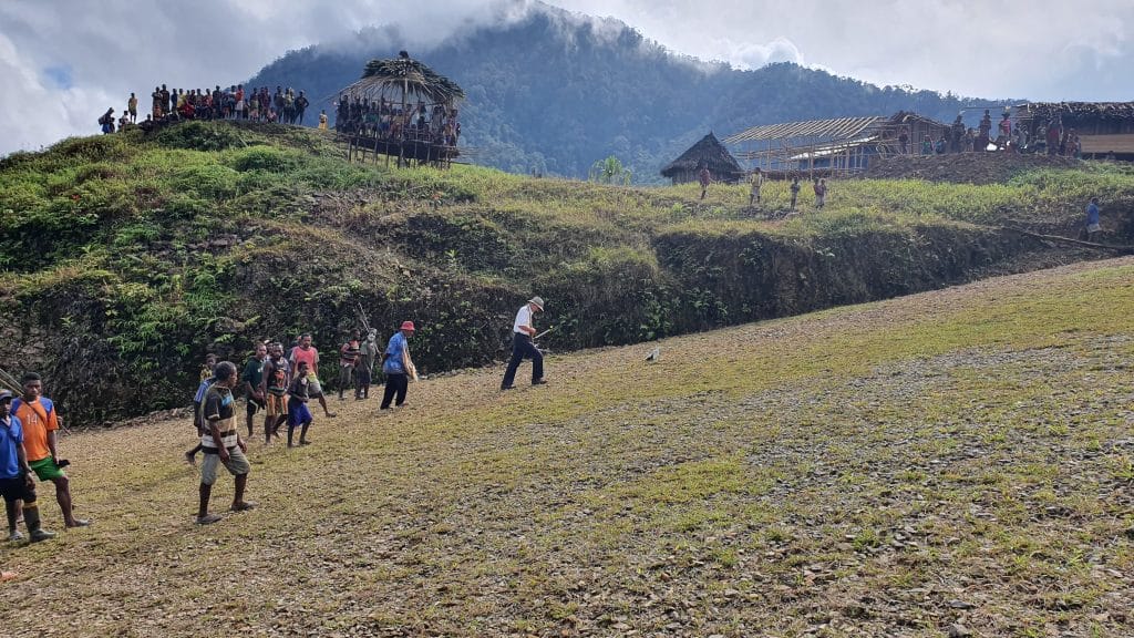
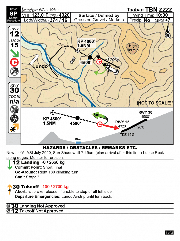
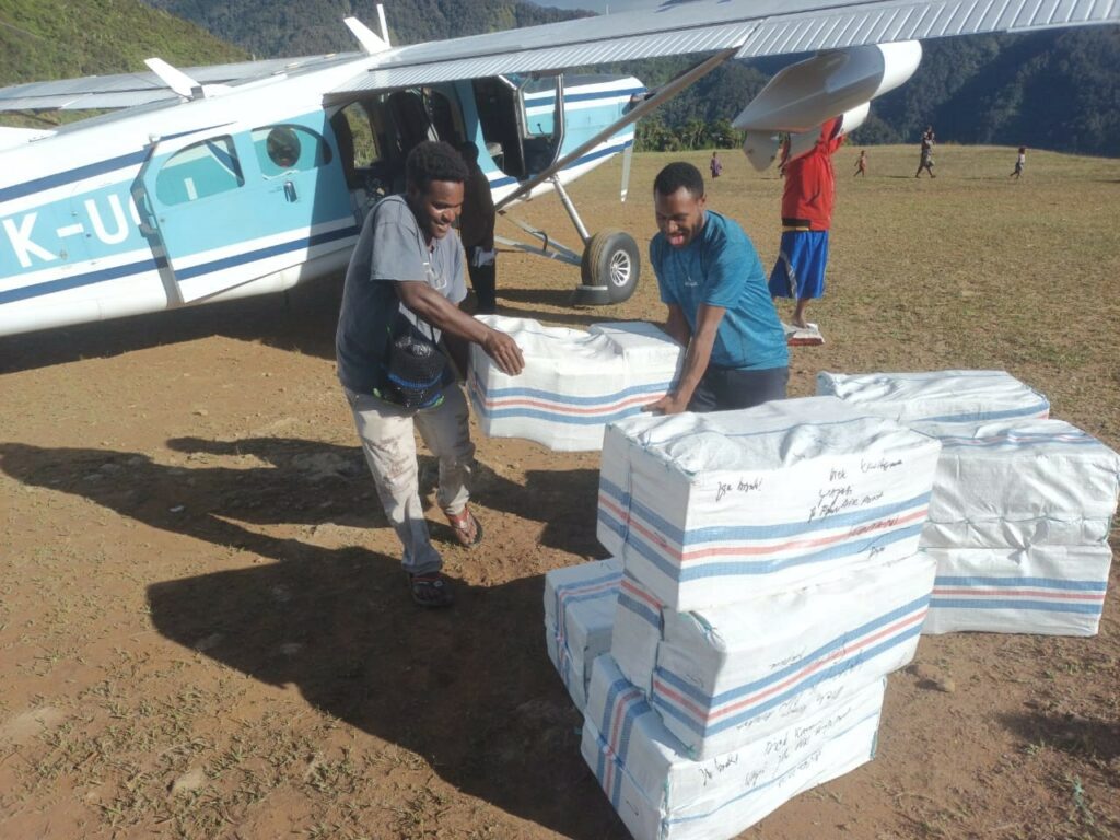
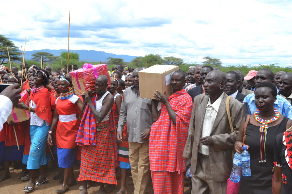
Interesting Fact: The Tauban runway was built using an erosion technique: washing dirt from the top of the runway to the bottom. Tauban also serves the village of Lundo, since YAJASI cannot use Lundo’s airstrip because it does not meet JAARS standards.
Time Saved: From YAJASI’s home base in Sentani to Tauban is a 50-minute flight. Overland travel is virtually impossible due to jungle, swamp, mountains, and rugged terrain void of roads. Pilot Brad McFarlane says, “The end of last week I flew eight people from Tauban to Oksibil for school and saved them a 6-day hike with a 20-minute flight.”
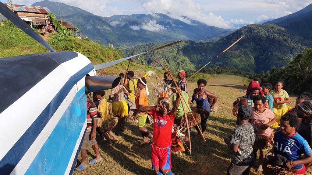
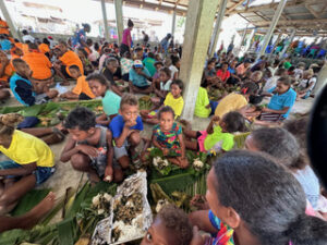
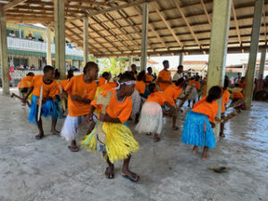
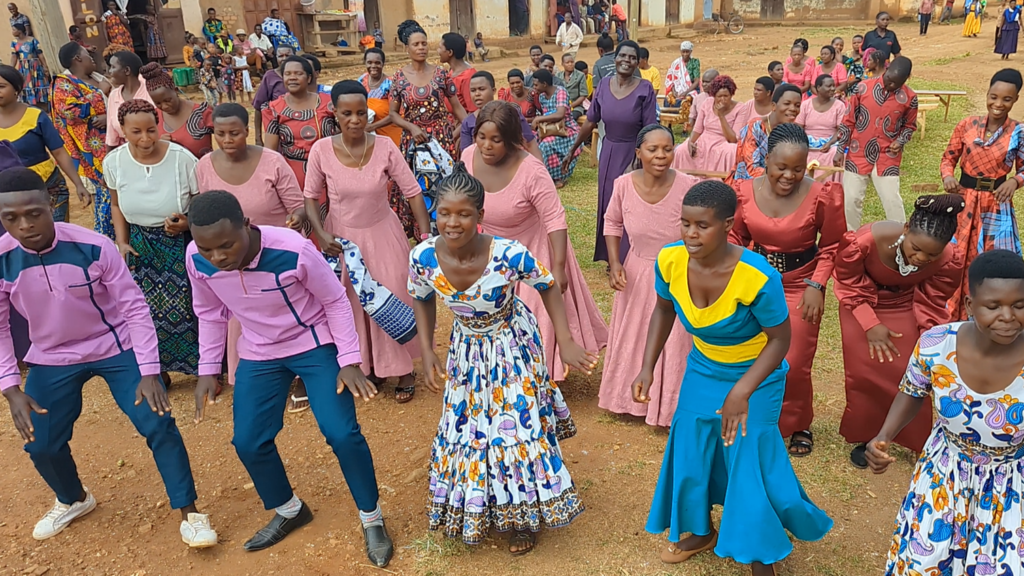
Tauban villagers had to move a lot of dirt to make their runway, using the erosion technique. They dug up the top of a hill and, using water and gravity, washed the excess soil down the hill to be compiled at the bottom of the runway. This technique saves many months of hard work but unfortunately is only available to those who build their runways on steep mountains. Photo credit Kars KronemanTauban from the air. Photo credit Kars KronemanThe Pilatus Porter PC-6 is sitting at the top of the runway. Photo credit Kars KronemanThis photo gives some idea of the steep slope at Tauban. Photo credit Kars KronemanPilot Kars Kroneman with villagers and the noken (string bag) they gave him as a sign of gratitude and appreciation. Photo credit Brad McFarlaneThe villagers celebrated the opening of Tauban with traditional dancing. Photo credit Kars KronemanPilot Brad McFarlane poses at the top of the runway with some local men dressed for the occasion. Photo credit Kars Kroneman
JAARS covers the last mile of missions using aircraft, boats, and off-road vehicles so that unreached people can experience God’s Word and His love.
Eric Peterson and Jim Entz replacing parts on a helicopter in the Philippines, ordered through a JAARS buyer and hand-carried by JAARS aviation personnel who came to help with the repair, circa 1980. The SIL Philippines aviation program closed in 2010.
We are grateful for the overwhelming support and prayers received during our involvement with Hurricane Helene Relief efforts.
For the past 40+ years, we've performed high altitude flight training for our global force of mission pilots and mechanics in those same mountains, valleys, and communities of Avery and Ashe Counties, areas that felt the wrath of Hurricane Helene. We know this area like the back of our hands. We know these people, and we've been blessed by their friendship and support. This enabled us to respond immediately to the crisis - before most anyone else - and it gave us an enormous heart to do what we could in the early days after the dangerous storm.
If you'd like to know more about JAARS and how we're reaching people in remote, mountainous places to share God's love, visit jaars.org
Thank you for the time and effort it took to give us this amazing update and recap of the beautiful news of how JAARS was able to help right in their own backyard. Thank you thank you thank you. Blessings
Sending your updates to our high school age grandson who is interested in aviation ❤️ An incredible ministry! Thank you!
JAARS has been such a blessing to us in our work overseas, and it is great to see you loving and serving your neighbors in this way. Praying for God's protection and blessing on you all. 🙏
Wow, just wow! It's so wonderful to see JAARS is showing the love of Christ both locally and globally. May the Lord continue to bless all the staff of JAARS.
Love being a part of JAARS!
It's great to think that God was preparing you for that specific work! You were able to minister better than others because of that preparation.
Mountain week 1982. What a great time of team building, and skills enhancement. I'm blessed to see the Jaars team giving back.
Thank you for all you have done over the years and for your continued ministry in WNC.
God Bless you and your pilots for all you are doing for these people in need!
Thank You for your work for the Lord and the people! God Bless You, All! Love & Prayers!
Thank you! God bless you for helping all those folks!
Thank you and God bless all of you at JAARS!!🙏❤️
Thanks for serving the Lord in this way!
Thank you for all that you have done.
Thank you for serving here at home!!!
HORRAY!!! Praise the Lord!
I was happy to donate, but I wonder if they still need your help. Maybe blankets and things to help with the cold.
Are you still doing your runs? Do we need to donate more for that?
Love those JAARS people!!
Barbara Creech Ohman
Thank you!
Do you have a Venmo account where we can donate by chance? Thank you! 🫶🏻
Pick apples at The Orchard at Altapass. When in the area, stop by this historic orchard that features more than 20 apple varieties, most of which are heirlooms that were planted at the beginning of the 20th century. Buy a peck from the shed or U-pick, visit the education center and butterfly garden, listen to live music, and follow the walking trails throughout the property. 1025 Orchard Road, Spruce Pine, NC 28777.
Browse for books at Little Switzerland Books and Bean. The cozy three-story complex opened in 1986 as a bookstore. It has since expanded to house 30,000 new, used, and old tomes, as well as a full-service coffee bar and bakery. Browse the gift selection to find a souvenir to bring home. 9426 NC 226A, Little Switzerland, NC 28749.
Guest Services
Guest Services works to ensure a positive experience for guests to JAARS base. They provide a wide range of services from food in our cafe, to managing our gift shop, to coordinating housing
Intern's Details and Eligibility
Key Dates
October 1 – February 28: Applications are open and interviews begin with select candidates
March & April: Interns are selected and notified
May 19-21: Interns move in
May 22: Mandatory 1-day orientation
May 22 – July 28: Interns serve at JAARS
July 28: Interns celebration
Eligibility
Qualifications for all interns include:
Completed sophomore year of college. While college freshman and sophomores have skills that are applicable to JAARS, Interns may not be the avenue to apply them. Applicants who will not have completed their first four semesters of college prior to the start of the internship can consider volunteering.
Interns are required to live in housing on the JAARS campus. Housing is not included in compensation. Monthly rent is $100, including a two-bedroom, two-bath apartment shared with a roommate; a two-bedroom, one-bath apartment shared with a roommate; or a one-bedroom, one-bath apartment with no roommate. Assignments depend on the number of interns in the cohort and available housing units. All apartments are fully equipped with furniture (including a small TV, but not a DVD player), linens (bedding and towels), and kitchen supplies.
Wages
Compensation for interns is $11 per hour.
Benefits
Benefits for interns include a life skills workshop (aka Life Hack), coverage of the cost of the Highlands Ability Battery and the corresponding career advising/coaching, outings, personal, spiritual, and professional development, and two paid holidays (Memorial Day and Fourth of July).
Work Schedule
All interns work full-time (40 hours per week). Most interns work 8:00 a.m. to 5:00 p.m. with an hour for lunch. However, work schedules may vary for certain projects that could require involvement in evening and weekend programs.
JAARS Interns’ Hiring Process
This guide details the steps we take to ensure a thorough and communicative hiring process. From job creation to onboarding, this list helps candidates understand where they are in the process and what to expect next.
Prayer
Before application season, our team goes to the Lord in prayer and asks that he would lead the right candidates to apply and that the team would honor him with their selection.
Post and Review
The Internship is posted on various sites, including the JAARS website and Handshake. Applications are submitted through the JAARS Applicant Tracking System (ATS). Applicants create an account in the ATS and complete the application, selecting the departments in which they are most interested. If more than one department is of interest, an applicant can mark up to three departments. The team then reviews all applications and resumes submitted.
Screen and First Interview
After the team reviews and screens candidates, they invite qualified applicants to an initial video interview with the current Human Resources Fellow and the Interns Coordinator. The purpose of the interview is to assess competencies and cultural fit, among other considerations, and explore specific department options.
Reference Checks
If a candidate has a successful first interview, the Human Resources Fellow conducts checks with the references provided on the candidate’s application.
Explore & Assign Departments
With gathered information from the first interview and the reference checks, the team then determines the best department to match the applicant’s skills.
Second Interview
Once a likely department assignment is selected, applicants are invited to a video interview with the Interns Coordinator, Human Resources Fellow, and project coordinator to explore team dynamics, department responsibilities, and possible projects.
Offer Letter
Official offer letters are sent to four-six candidates for each Interns Cohort. Candidates typically have one–two weeks to respond to offer letters.
Offer Acceptance and Onboarding
Once candidates accept their offers, the current Human Resources Fellow coordinates the completion of criminal background checks and all onboarding paperwork. New interns respond to correspondence from the Human Resources Fellow and the Interns Coordinator as their start date approaches.
The hiring process takes anywhere from 30–120 days. The process varies for individuals depending on candidate pool and application completion date.
Information & Digital Technologies Ops
This team ensures JAARS has the technology and business processes it needs and the understanding to utilize them for maximum effectiveness. They support JAARS by servicing desktops, laptops, servers, networking, WiFi, project management, systems support, and systems analysis and documentation.
Land and Sea Ops
Through boat, 4WD, and motorcycle safety training, Land and Sea Ops ensure workers on the field travel safely. They also maintain and repair training fleet vessels and vehicles.
Air Ops
More information about our aviation internship coming.
International Aviation Safety
More information coming.
Human Resources
Human Resources supports JAARS through talent acquisition and guarding good workplace practices.
Museums
The Museum of the Alphabet and the Cardenas Building preserve and share the history of JAARS and Bible translation with the public. The team carries out day-to-day operations, programs, and events, manages the museum, maintains the current museum collection, plans and installs new exhibits, and designs and implements museum programming to create an engaging experience.
Experiences
The Experiences team serves and promotes JAARS through experiential marketing. They develop and implement face-to-face experiences such as Missions at the Airport, Vision Flights, JAARS’ aviation camp, and more.
Marketing
The Marketing team develops and executes marketing plans and strategies to increase awareness of JAARS through content creation and media campaigns across a diversity of platforms.
Accounting
The accounting team carries out daily operations and large projects that keep JAARS’ finances operating. They specialize in not-for-profit accounting, Enterprise Resource Planning (ERP) system conversion, and accounting procedures and best practices.
Training
The Training department interacts with the entire JAARS base and partners around the globe, providing training relating to workplace culture, cross-cultural communication, multi-generational teams, and spiritual vitality.
Purchasing & Logistics
The Purchasing and Logistics team manages the supply chain through purchasing, contracts, inventory, and shipping and receiving. Through Purchasing and Logistics, the rest of JAARS has the physical resources needed to cover the last mile of missions.
TCK Care and Education
Third culture kids (TCKs) are multicultural children. TCK Care and Education provides families at JAARS base for training, furlough, or full-time service with childcare and programming that suits the unique needs of TCKs. MK Station is the daycare for young children and babies, while the MK Youth & Young Adults team hosts youth groups and disciples the next generation of TCKs.
Software Development
A team at JAARS is developing and supporting the FlightSpan app, an aviation platform built specifically for mission aviators and others flying in remote environments. Areas of service include developing, troubleshooting, and testing new features and bug reports.
Research & Development and Engineering Ops
This department innovates ways to improve safety by designing parts to improve the utilization and efficiency of mission transportation.
Advancement Ops
Through developing and nurturing relationships with major donors, hosting events, meeting with potential partners, and writing grant proposals, this department ensures JAARS has the funds to carry out our work.
Global Ops
The Global Ops team receives project and program proposals from global partner organizations, and develops future JAARS hubs to support partner organizations by providing transportation solutions and training to cover the last mile of missions.
October 3, 2024—MISSION BANQUET
AWARENESS AND MISSION BANQUET
October 3, 2024 6:00 p.m.–9:30 p.m.
Franconia Heritage Banquet Hall 508 Harleysville Pike Telford, PA 18969
Come join JAARS for a delicious dinner and program where you can hear from missionary aviators! Learn how we Cover the Last Mile of Missions using special purpose aircraft, boats, and 4 wheel drive vehicles. There will be food, fellowship, and breakout sessions where you can meet and greet our team.
Tickets are $40/person and can be reserved by emailing martha.detweiler@jaars.org. We will have them for you at the door.
October 5–6, 2024—Franconia Community Park
October 5–6, 2024 10:00 a.m.–6:00 p.m.
Franconia Community Park 651 Allentown Rd, Telford, PA 18969
We are excited to partner with the local police department for their annual FALL FESTIVAL. This is a great weekend to bring out the family for a lot of fun and activity. JAARS will provide helicopter rides for the weekend. Come early! We sell out quickly! Rides are 10-6 each day.
Carolina Presbyterian Church 406 Renee Ford Road Locust, NC
JAARS will be participating on Saturday as a part of the church’s weekend Mission Conference. Helicopter rides will be offered from 10:00 a.m. to 5:00 p.m. Come hear about the work around the globe and learn how YOU can be a part of Covering the Last Mile of Missions!
Come see how JAARS Covers The Last Mile Of Missions!
This event is part of a church Mission Fair.
Helicopter Rides: $45/per person
August 23-24, 2024—Pittsfield Airport
August 23–24
9:00 a.m.–5:00 p.m.
Pittsfield Airport
176 Harrison St.
Pittsfield, ME 04967
207.487.5213
Airplane Rides: $40/per person
Helicopter Rides: $45/per person
August 25, 2024—Cross Point Church
August 25
1:00 p.m.–5:00 p.m.
Cross Point Church
1476 Broadway
Bangor, ME 04401
(Helicopter rides only)
Helicopter Rides: $45/per person
July July 13, 2024—McPherson Airport, 1000 S. 81 Bypass McPherson, Kansas
EAA AirVenture Wittman Regional Airport 1000 S. 81 Bypass McPherson, Kansas
Our Missions at the Airport team will be at the McPherson, KS Airport fly-in and open house providing airplane rides in a Cessna 206 and Helio Courier. Come meet the team and learn about the work of JAARS and the Last Mile Challenge of Missions.
Rides from 10:00 – 6:00 Tickets: $40/per person
on Sunday morning, July 14, JAARS representatives are speaking at Medora Community Bible Church, 8322 Medora Rd, Hutchinson, KS. Sunday School is at 9:00 a.m. and Worship is at 10:15 a.m.
July 22-28, 2024—EAA AirVenture, Wittman Regional Airport, Oshkosh, WI
EAA AirVenture Wittman Regional Airport 3000 Poberezny Rd Oshkosh, WI
The JAARS Missions at the Airport team will represent JAARS at the Experimental Aircraft Association AirVenture 2023, exhibiting a Cessna 206 and a Robinson R66 helicopter. Come hear various JAARS speakers at the exhibit site 23, just northwest of exhibit hangar C. Our Helio Courier will fly a demonstration during the airshow on Thursday, July 25, and will be on static display for visitors when not flying. Our Pilatus PC-6 will be the jump plane for the skydivers at the beginning of the daily airshows.
June 8, 2024—Shelby-Cleveland County Airport (KEHO),Shelby NC
Shelby-Cleveland County Airport (KEHO) 830 College Avenue Shelby NC 28152
Airport fly-in and open house. 10:00 – 4:00. Airplane and helicopter rides provided by JAARS. The airport open house is free but there will be a cost for rides; Airplane $40/person, Helicopter $45/person. Community fly-in and car show.
May 24-27, 2024—America’s Keswick,Whiting, NJ
America’s Keswick 601 Route 530 Whiting, NJ
The JAARS Missions at the Airport team will be at America’s Keswick in Whiting, NJ for Keswick’s Memorial Day Weekend Conference season kickoff. JAARS is the featured mission for the conference and will have speakers at various times during the weekend. The helicopter team will offer helicopter rides to conference attendees and the general public on Friday through Monday.
Dates and times: Friday 12:00 – 5:00, Saturday 9:00 – 5:00, Sunday 2:00 – 5:00, and Monday 9:00 – 5:00.
Helicopter tickets – $45/person
May 18, 2024—Spartanburg Airport, Spartanburg, SC
Spartanburg Airport Open House 500 Ammons Rd. Spartanburg, SC 29306
Airport fly-in and open house. 10:00 – 4:00. Helicopter rides provided by JAARS. The airport open house is free but there will be a cost for rides; Helicopter $45/person. Community fly-in and airport open house.
Apprentices train with experienced aviators and technicians to hone their skills for deployment to a JAARS hub. In addition, discipleship conversations revolve around preparing for missions.
After you have finished your apprentice training, you are expected to serve a three-year term overseas and one year back at JAARS base in North Carolina. At that time, discussions will be had about longer term service with JAARS.
A JAARS Apprentice candidate must be a believer with a deep and growing relationship with God, must agree to the JAARS statement of faith, must be an active member of a biblically-solid church, and embrace the vision and mission of JAARS.
An apprentice must also have the appropriate aviation certifications, personal attributes, and be willing to pursue overseas deployment with JAARS. Aviation certifications include:
Pilot: Commercial pilot license with instrument rating and valid Class II FAA Medical or equivalent (Prefer: High performance and tailwheel aircraft endorsement)
Mechanic: Airframe and Powerplant certificates, or ICAO equivalent
An Apprentice’s spouse, if applicable, must be supportive and willing to be trained in preparing for an overseas assignment.
In addition to ongoing aviation training costs and significantly subsidized housing costs, apprentices are paid $16 an hour. After the successful completion of the apprenticeship, staff members are paid a salary set in accordance with their qualifications/certification.
Apprentices receive one-on-one discipleship and a thorough compensation and benefits package that includes significantly subsidized housing, insurance, retirement, and paid time off.
Pre-field training beyond aviation training—such as cross-cultural training, security training, language acquisition training, prayer partnership development training, and more—is also a part of the apprenticeship. Spouses of apprentices should plan to take part in this aspect of training as well.
Apprentices typically train and/or serve for 40 hours a week from 8 a.m. to 5 p.m. with an hour lunch break. However, some training events will require longer hours and travel. Discipleship meetings typically occur during the 40 hours per week.
There will be important opportunities for apprentices to participate in relationship building with their deployment team and/or other apprentices, forming essential bonds before going overseas. While some of that bonding will happen during work hours, it’s vital for the whole deployment team, including spouses and children, to socialize outside of work hours.
Apprentices should also develop and cultivate a partnership team who will support them through prayer. They do this through regular newsletters and communication with partners and/or their local church outside of work hours. As part of their apprenticeship training, they will learn how to build their prayer team and will receive periodic check-ins with Apprentices staff on their progress.
By joining Apprentices, you are taking an active step in reducing barriers, easing burdens, and delivering God’s Word in a remote location overseas. You will receive training that will enable you to serve at an overseas JAARS hub.
After you have gone through the interview and assessment process, if JAARS personnel feel confident that you and your family are a good fit for the program, you will receive communications from JAARS Human Resources, with a formal offer letter to join JAARS Apprentices.
Celebrate! Complete any trainee onboarding paperwork sent by JAARS, and set up a meeting with the leadership of your local church. Share with them what you are doing and ask them to partner with you in prayer.
Apprentices rent fully-furnished apartments on the JAARS Base. Unmarried apprentices may share with another apprentice of the same gender. Apartments include a kitchen, cooking appliances, living room, bedroom(s), and a shared bathroom. Married apprentices work directly with JAARS Housing to find the unit that works for their family. Monthly rent is $150, including utilities, internet, and laundry facilities.
Apartments are fully furnished, so bring only what you really need, such as clothes and personal supplies. Decorations can also never hurt! Check out a video walkthrough of one of the two-bedroom, two-bath apartments at this link.
The JAARS Base is located about 6 miles from Waxhaw, North Carolina, and 12 miles from Lancaster, South Carolina. While a car is not required for JAARS Apprentices, most people find it helpful to bring their own cars.
Spouses of apprentices receive bimonthly discipleship like apprentices do.
There are childcare options available, a few of which are listed below. Read about all of the children and youth resources available here.
Apprentices may choose to enroll their children in the JAARS MK Station at the Apprentices’ expense. MK Station is a preschool facility for children from 3 months of age through kindergarten.
Summer Safari is a summer program that serves first grade through fifth grade students.
Middle schoolers and high schoolers may participate in the JAARS youth group.
Families will also receive training in preparation for serving overseas.
JAARS is located 30 minutes south of the outer beltway of Charlotte, North Carolina, and 20 minutes from Lancaster, South Carolina. We are 10 minutes from Main Street in “downtown” Waxhaw.
The JAARS Base is a beautiful 600+ acre rural campus with recreational areas and a swimming pool, 18-hole disc golf course, library, dining room, health clinic, RV park, childcare facilities, and youth ministries. In the community, one can find game-night groups, volleyball groups, Bible studies, as well as other special events.
Waxhaw, North Carolina, is a family-friendly, historic, small town, surrounded by a natural backdrop of rolling hills, horse country, and outdoor recreation. It has creative and performing arts, vibrant music, antiques, and good old-fashioned parades.
Lancaster, South Carolina, is also a historic small town with a state university campus, shopping areas, several festivals and events, as well as a yearly Christmas parade.
Recreational activities in the Waxhaw area include escape room games, mini golf, beautiful parks, delicious places to eat, and much more! Here are some examples of what is in the area:
Cane Creek Park: biking, walking, kayaking, picnicking
You (and your spouse) will meet bimonthly (separately) with your discipler. Your discipler has conversation topics designed to help you prepare spiritually for your overseas deployment, but you and your discipler can also tailor your meetings to what’s most effective for you. In addition, you (and your spouse) will attend our InterCultural Communications Course, which focuses on spiritual preparation for overseas service. There are also many good churches in the Waxhaw area where you can grow in your faith.
During Apprentices, you will train with experienced mission aviators, most who have prior overseas experience. They will tailor the training to your learning needs. Some learning opportunities may include: training classes, Pre-Field Orientation, and Mountain Week.
JAARS will provide opportunities for team-building with your apprenticeship group as well as integration into the larger JAARS community.
During your apprenticeship, you will have the opportunity to develop teamwork dynamics with other missions-minded individuals. Some of these individuals will be your future overseas teammates, enabling you to build relationships before you go to the field.
Outside of work, there will be additional opportunities to build community with the other apprentices and their families.
During your apprenticeship, you will have conversations with a task force of Human Resources and Air Operations representatives who will work with you to determine the best fit for you and your family.
By the end of your apprenticeship, you will have your deployment location and may know many members of your deployment team. The second half of your apprenticeship will focus on training, both cultural and technical, specific to your deployment location.
Once you are proficient in the necessary skills, your apprenticeship training will end. This training can take up to two years. You can expect to be deployed as soon as possible after your apprenticeship. The political climate, visa applications, language acquisition training, and other factors will be considerations in the timing of your deployment.
You can expect to be deployed for three years before returning to the JAARS Base in North Carolina. This time of “home assignment” will be defined prior to your return to the United States.
A JAARS Interns candidate must be a believer with a deep and growing relationship with God, can agree to the JAARS statement of faith, and embraces the vision and mission of JAARS. Beyond that, we require the completion of four semesters of college and a learner attitude.
Benefits for interns include a life skills workshop (aka Life Hack), coverage of the cost of the Highlands Ability Battery and the corresponding career advising/coaching, outings, personal, spiritual, and professional development, and one paid holiday (Memorial Day).
Interns are expected to participate in one life hack and two outings during their 10-week internship. This is approximately 9 hours outside of work hours.
All one-hour coaching times and group Bible studies are during work hours. Two hours of career advising with a Highlands Ability Battery coach is paid time, however the assessment itself is approximately three hours of unpaid time. Life hacks and outings are not part of paid time but will enhance your overall experience as an Intern.
All interns help departments at JAARS complete crucial projects that will in turn support mission workers overseas. Each project contributes to the vision and mission of JAARS in different ways. This is a great topic to discuss in the second and third interview with the Interns Coordinator and project manager.
Yes. If there is an interest in staying at JAARS after the internship, we encourage interns to pursue JAARS Fellows after they graduate. Other opportunities to stay connected to JAARS could be through volunteering.
After you have gone through the three interviews, if the HR team, Interns Team, and project manager feel confident in you as the top choice, you will receive a formal offer letter to join JAARS Interns.
Celebrate this exciting, new step. Also, complete all of the onboarding paperwork that is sent to you by the HR Fellow and Interns Coordinator. If you have any questions about that paperwork, reach out via phone or email.
Interns rent fully-furnished apartments at the JAARS Center. Usually these are shared, and each person has their own room and a shared bathroom. Apartments include a kitchen, cooking appliances, living room, one or two bedrooms, and one or two bathrooms. Monthly rent is $100, including, including utilities, internet, and laundry facilities.
Apartments are fully furnished, so only bring what you really need, such as clothes and personal supplies. Decorations can also never hurt! Check out photos and a video walkthrough of one of the two bedroom, two bath apartments at this link.
Interns participate in approximately one life hack during the internship to add various life skills to their repertoires. We also do approximately two fun outings. These are just the scheduled activities; you will have plenty of time for recreational community building activities with your cohort and the JAARS Fellows on campus.
With the exception of occasional meals during outings and life hacks, interns are responsible for their own meals. Campus housing is equipped with a kitchen that includes pots, pans, dishes, and utensils.
The JAARS Center is located about 6 miles from Waxhaw, North Carolina, and 10 miles from Lancaster, South Carolina. While a car is not required for JAARS Interns, most people find it helpful to bring their own car.
JAARS is located 30 minutes south of the outer beltway of Charlotte, North Carolina, and 20 minutes from Lancaster, South Carolina. We are 10 minutes from Main Street in “downtown” Waxhaw.
JAARS is located on a beautiful 500+ acre rural campus with recreational areas and a swimming pool, library, dining room, health clinic, RV Park, childcare facilities, and youth ministries. In the community, one can find game night groups, volleyball groups, Bible studies, as well as other special events.
Waxhaw, North Carolina, is a family-friendly, historic, small town, surrounded by a natural backdrop of rolling hills, horse country, and outdoor recreation. It has creative and performing arts, vibrant music, antiques, and good old-fashioned parades.
Lancaster, South Carolina, is also a historic, small town with a state university campus, shopping areas, several festivals and events, as well as a Christmas parade each year.
Recreational activities in the Waxhaw area include escape rooms, mini golf, beautiful parks, delicious places to eat, and much more! Here are some examples of what is in the area:
Cane Creek Park – biking, walking, kayaking, picnicking
All interns positions are full-time (40 hours per week). Most positions work 8:00 am to 5:00 with an hour for lunch. However, work schedules vary for certain projects that require involvement in evening and weekend programs.
You will meet weekly with the other interns in your cohort as well as an Interns team member for a group Bible study. Additionally, you will meet weekly with a coach, who will get to know you, and ultimately disciple you into a more mature follower of Christ.
You will have a project manager whom you will meet with weekly. They will work with you through the various aspects of your project(s). In addition to your project manager, you will receive professional coaching. This coach (same as above for spiritual coaching) will talk with you about your areas of interest, the parts of the job you like and may not like, and will help you navigate your internship and even your career beyond JAARS. Additionally, you will take the Highlands Ability Battery and will receive career advisement from a Highlands Consultant.
The Highlands Ability Battery (HAB) is a human assessment tool that objectively measures your natural abilities by asking you to perform specific tasks or exercises. As part of the Highlands Whole Person Model, the HAB is the foundation and starting point to identify the career best suited for you.
The HAB is unique in that it measures your abilities based on performance rather than perception. Exercises such as recreating designs from memory, manipulating blocks in space, and putting images in logical sequence are some of the virtual tasks you are asked to perform within a set amount of time. Results based on timed performance are far more reliable than results based on self-perception or personal opinion.
JAARS partners closely with SIL International, 100+ organizations of the Wycliffe Global Alliance, and with other local and global organizations. The majority of our supported staff are Wycliffe members (their funding and sending organization) assigned to JAARS, or seconded to SIL International and located at JAARS.
Applications close: March 31, 2024 Candidate screening and offer letters: March-May Start date: September 9, 2024 End date: Approximately two years from start date
Eligibility Mechanics, pilots, and pilot-mechanics with the appropriate certifications are eligible to apply. Qualifications for all apprentice positions include:
biblical Christ-follower
value of and commitment to global ministry
active member of a biblically solid church
completion of initial certifications
Pilot: a Commercial pilot license with instrument rating and valid Class II FAA Medical or equivalent (Preferred: High performance and tailwheel aircraft endorsement)
Mechanic: Airframe and Powerplant certificates, or ICAO equivalent
willing to develop a prayer-focused partnership team
willing to serve overseas in a remote location at a new JAARS hub
learner attitude and a collaborative approach to work
additional qualifications such as those found in the job descriptions
Housing Apprentices may choose to live in housing on the JAARS campus. On-base rent, which is subsidized, is $150 per month. Accommodations for single apprentices include: a two-bedroom, two-bath apartment shared with a roommate; a two-bedroom, one-bath apartment shared with a roommate; or a one-bedroom, one-bath apartment with no roommate. Assignments depend on the number of apprentices and available housing units. Married apprentices work directly with JAARS Housing to find a unit that works for the needs of their families. All apartments are fully equipped with furniture (including a small TV, but not a DVD player), linens (bedding and towels), and kitchen supplies.
Wages Compensation for apprentices during their apprenticeship is $16 per hour. Following the successful completion of their apprenticeship, they will have a paid salary set per their qualifications/certification.
Benefits Apprentices are eligible for health insurance benefits and receive 10 vacation PTO (paid time-off) days, 12 sick PTO days, and 8 holiday PTO days (plus the PTO days during Christmas break from Christmas Eve through New Year’s Eve).
Training Schedule All apprentices positions are full-time (40 hours per week). Most of the time, apprentices train from 8:00 a.m. to 5:00 p.m. with an hour for lunch. However, work schedules vary for certain projects and training events that require involvement in evening and weekend programs.
Hiring Process for JAARS Apprentices
This guide details the steps we take to ensure a thorough and communicative selection process. From applying to onboarding, this list helps candidates understand where they are in the process and what to expect next.
1.Prayer
Before posting a position, the Apprentices Admin team goes to the Lord in prayer and asks that he would lead the right candidates to apply and that the team would honor him with their selection.
2.Post & Review
The job is posted on various sites, including the JAARS website. Applications are submitted through the JAARS Applicant Tracking System (ATS). Applicants select the position they are most interested in, create an account in the ATS, and complete the application. The team then reviews all applications and résumés submitted.
3.Screen & First Interview
After the team reviews and screens candidates, they invite qualified applicants to an initial phone interview with a Human Resources staff member. The purpose of the interview is to assess competencies and cultural fit, among other considerations.
4. Reference Checks
The Human Resources staff member conducts checks with the references provided on the candidate’s application. Once those references are completed, the Apprentices Admin team, along with Air Operations personnel, decide which candidates to invite to a second interview.
5. Second Interview
The team then provides information on a qualified candidate to the appropriate supervisor for further review and a second-round Zoom interview. This interview includes the interviewee, the Apprentices Manager, and an Air Operations training representative.
6. On-site Consultation/Skills Assessment
Unless already accomplished, candidates visit the JAARS Base to complete a skills/technical consult. These will be scheduled when/if the screening team chooses.
7. Offer Letter
Official offer letters are sent to twelve candidates for each Apprentices cohort. Candidates typically have one–two weeks to respond to offer letters.
8. Offer Acceptance and Onboarding
Once candidates accept their offers, the Human Resources staff coordinates the completion of criminal background checks and all onboarding paperwork. New apprentices then register for the Intercultural Communications Course and respond to correspondence from the Human Resources staff and the Apprentices Coordinator as their start date approaches.
The selection process takes anywhere from 30–120 days. The process varies for individuals depending on the position, candidate pool, application date, and the cohort for which a candidate is applying.
A JAARS Fellows candidate must be a believer with a deep and growing relationship with God, can agree to the JAARS statement of faith, and embraces the vision and mission of JAARS. Beyond that, we require an Associates or Bachelor’s degree (or life/experience equivalent – i.e. YWAM Discipleship Training School, relevant work experience, etc.) and a learner attitude.
Beyond the $12 per hour compensation, the Fellows benefits package includes paid holidays, sick days, and vacation days. Health insurance is also available for those who need it. Additional benefits include community outings, life hacks (life skills classes), and enrollment in the Perspectives on the World Christian Movement course.
Fellows are expected to participate in one life hack and one outing a month. This is approximately 6 hours per month outside of work hours. Fellows spend 1-2 hours per week in intentional community time with their cohort(s). This time could include games, food, conversation, etc.
All one-hour spiritual coaching and professional coaching times are during work hours. During the Perspectives on the World Christian Movement course, fellows spend 6 hours on content during work hours. Life hacks and outings are not part of paid time but will enhance your overall experience as a Fellow.
All fellows help departments at JAARS fulfill crucial roles that will in turn support mission workers overseas. Each position contributes to the vision and mission of JAARS in different ways. This is a great topic to discuss in the second interview with the hiring manager.
Yes. Historically, we have had approximately 39% of fellows join JAARS staff after the completion of their fellowship. Some of those have filled short-term roles, while others have filled long-term staff roles. If there is an interest in staying at JAARS after the fellowship, fellows are encouraged to discuss potential opportunities with their supervisor/professional coach and the HR Director.
After you have gone through an initial interview, you will be invited to a Hiring Manager interview where, if the HR team and hiring manager feel confident in you as the top choice, you will receive a formal offer letter to join JAARS Fellows.
Celebrate this exciting, new step. Also, complete all of the onboarding paperwork that is sent to you by the HR Fellow and Fellows Coordinator. If you have any questions about that paperwork, reach out via phone or email.
Fellows rent fully-furnished apartments at the JAARS Center. Usually these are shared, and each person has their own room and bathroom. Apartments include a kitchen, cooking appliances, living room, one or two bedrooms, and one or two bathrooms. Monthly rent is $100, including utilities, internet, and laundry facilities.
Apartments are fully furnished, so only bring what you really need, such as clothes and personal supplies. Decorations can also never hurt! Check out photos and a video walkthrough of one of the two bedroom, two bath apartments at this link.
Fellows participate in approximately one life hack per month to add various life skills to their repertoires. We also do approximately one fun outing every other month. These are just the scheduled activities; you will have plenty of time for recreational community building activities with your cohort. Read more about outings and life hacks in the “How do we invest in our fellows?” section of this webpage.
With the exception of occasional meals during outings and life hacks, fellows are responsible for their own meals. To encourage community, fellows are asked to eat meals together often. Campus housing is equipped with a kitchen that includes pots, pans, dishes, and utensils.
The JAARS Center is located about 6 miles from Waxhaw, North Carolina, and 10 miles from Lancaster, South Carolina. While a car is not required for JAARS Fellows, most people find it helpful to bring their own car.
JAARS is located 30 minutes south of the outer beltway of Charlotte, North Carolina, and 20 minutes from Lancaster, South Carolina. We are 10 minutes from Main Street in “downtown” Waxhaw.
JAARS is located on a beautiful 500+ acre rural campus with recreational areas and a swimming pool, library, dining room, health clinic, RV Park, childcare facilities, and youth ministries. In the community, one can find game night groups, volleyball groups, Bible studies, as well as other special events.
Waxhaw, North Carolina, is a family-friendly, historic, small town, surrounded by a natural backdrop of rolling hills, horse country, and outdoor recreation. It has creative and performing arts, vibrant music, antiques, and good old-fashioned parades.
Lancaster, South Carolina, is also a historic, small town with a state university campus, shopping areas, several festivals and events, as well as a Christmas parade each year.
Recreational activities in the Waxhaw area include escape rooms, mini golf, beautiful parks, delicious places to eat, and much more! Here are some examples of what is in the area:
Cane Creek Park – biking, walking, kayaking, picnicking
This class enhance your overall understanding of your place in the Great Commission and how to effectively engage in it. Our God is a missional God, therefore JAARS values missions. This course prepares kingdom workers. Whether God calls you to missions or the marketplace after your fellowship, you will be equipped to advocate for missions in all future endeavors.
Perspectives is structured like a college-level course. Read the course overview here. Fellows take the course at a certificate level which includes videos, readings, reviews, discussions, and an integrated project.
All fellows positions are full-time (40 hours per week). Most positions work 8:00 am to 5:00 with an hour for lunch. However, work schedules vary for certain positions that require involvement in evening and weekend programs.
You will meet weekly with a spiritual coach, who will get to know you, and ultimately disciple you into a more mature follower of Christ. Your spiritual coach will be assigned to you after you’re given the opportunity to interact with multiple spiritual coaches and you have provided input as to which individual you’d enjoy working with.
You will have a professional coach whom you will meet with weekly, this individual also happens to be your manager/supervisor. They will work with you through the various aspects of your role, talking to you about areas of interest for you, the parts of the job you may not like. They are there to help you navigate your job and even into your career beyond JAARS.
JAARS partners closely with SIL International, 100+ organizations of the Wycliffe Global Alliance, and with other local and global organizations. The majority of our supported staff are Wycliffe members (their funding and sending organization) assigned to JAARS, or seconded to SIL International and located at JAARS.
Fellows Details & Eligibility
Eligibility
Recent graduates, graduate students, and business professionals are eligible to apply for fellowships. Qualifications for all fellows positions include:
biblical Christ-follower
value global ministry
completion of an accredited post-secondary degree (preferred, though equivalent experience such as: completing YWAM Discipleship Training School, University of the Nations, Master’s Commission, or similar real-life experience may be considered)
Housing
Fellows are required to live in housing on JAARS Center. Housing is not included in compensation. Monthly rent is $100, including utilities, internet, and laundry facilities. Singles are assigned to a 2-bedroom, 2-bath (or 2-bedroom, 1-bath) apartment with one roommate or a 1-bedroom, 1-bath apartment with no roommate. This depends on the number of Fellows in the cohort and available housing units. Married fellows work directly with JAARS housing to find a unit that works for the needs of their family. All apartments are fully equipped with furniture (including a small TV, but not a DVD player), linens (sheets and towels), and kitchen supplies.
Wages
Fellows are compensated $12 per hour.
Benefits
Fellows are eligible for health insurance benefits and receive 10 PTO (paid time off) days, approximately 10 sick days, and paid holidays (approximately 8). Additional benefits for fellows includes life skills training (a.k.a. Life Hacks) and coverage of the costs of the Perspectives on the World Christian Movement course and outings.
Work Schedule
All fellows positions are full-time (40 hours per week). Most positions work 8:00 am to 5:00 with an hour for lunch. However, work schedules vary for certain positions that require involvement in evening and weekend programs.
Papua New Guinea: Kaluli
Translation began 1985, SIL involvement 1991
Published NT + Genesis and Ruth2022, Dedication date February 2024
Available in print, audio, and dramatized NT, Gospel of Mark video. MP3 with solar-powered projection units
JAARS provided aviation support.
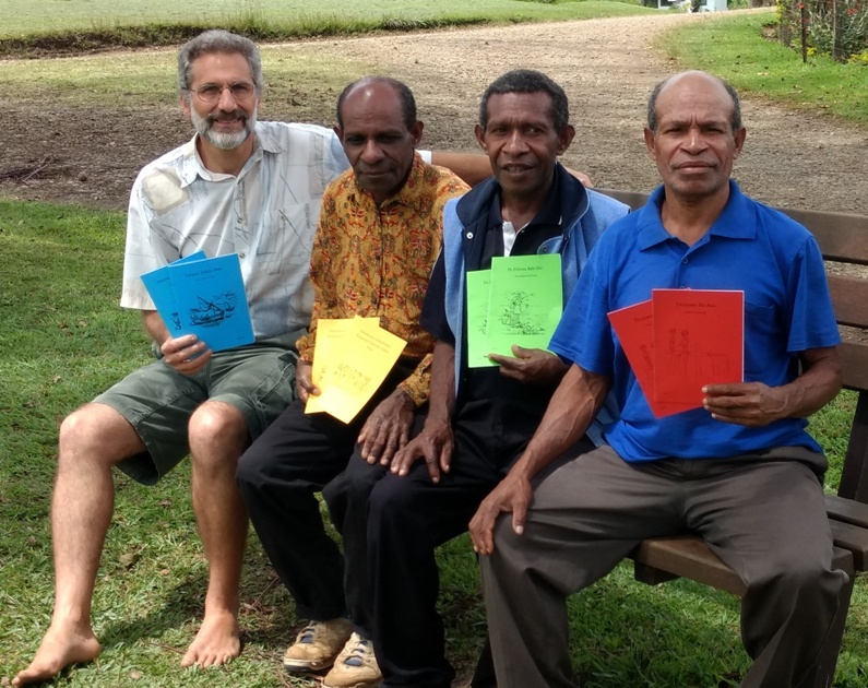
Philippines: Karao
3,700+ Speakers
Published NT 2023
Available in print
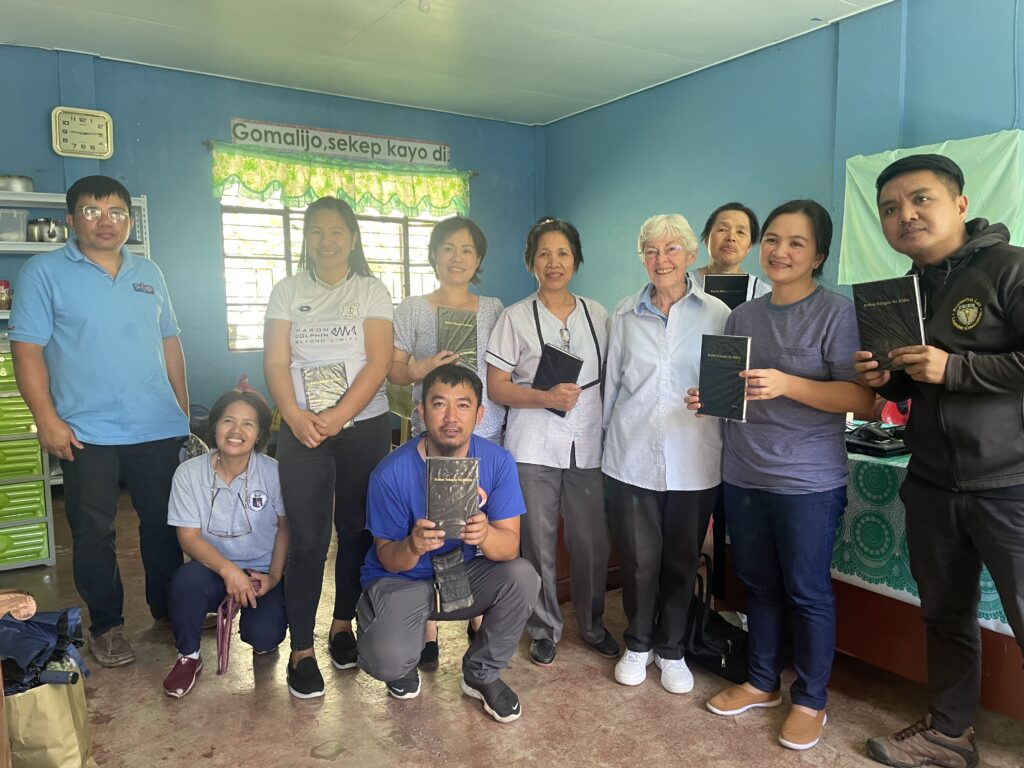
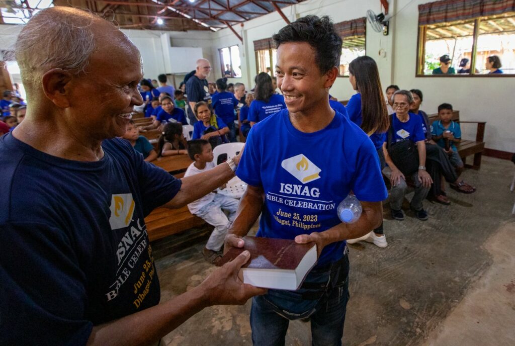
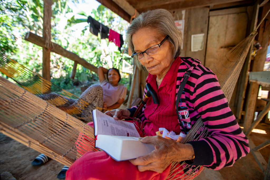
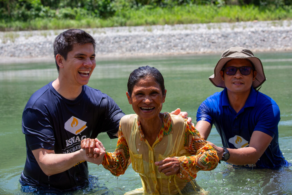
Philippines: Isnag
125,000 Speakers
Translation began 1956
Published NT 1982, Full Bible 2023, Dedication date June 25, 2023
Available in print, and the Jesus film
Between 1959–2010 JAARS provided 17 pilots, 5 mechanics, radio people, support personnel, and computer specialists. For the June 2023 dedication JAARS photographer Rodney Ballard captured the event on film.
JAARS Shipping and other services on the Base all assisted the translators in their work.
*Name changed for security reasons
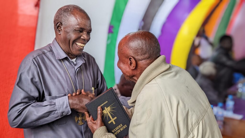
Brazil: Kulina
3,000 Speakers (in Brazil)
Published NT 2021, Dedicated June 1, 2021
Available in print, audio, digital, and Gospel recordings
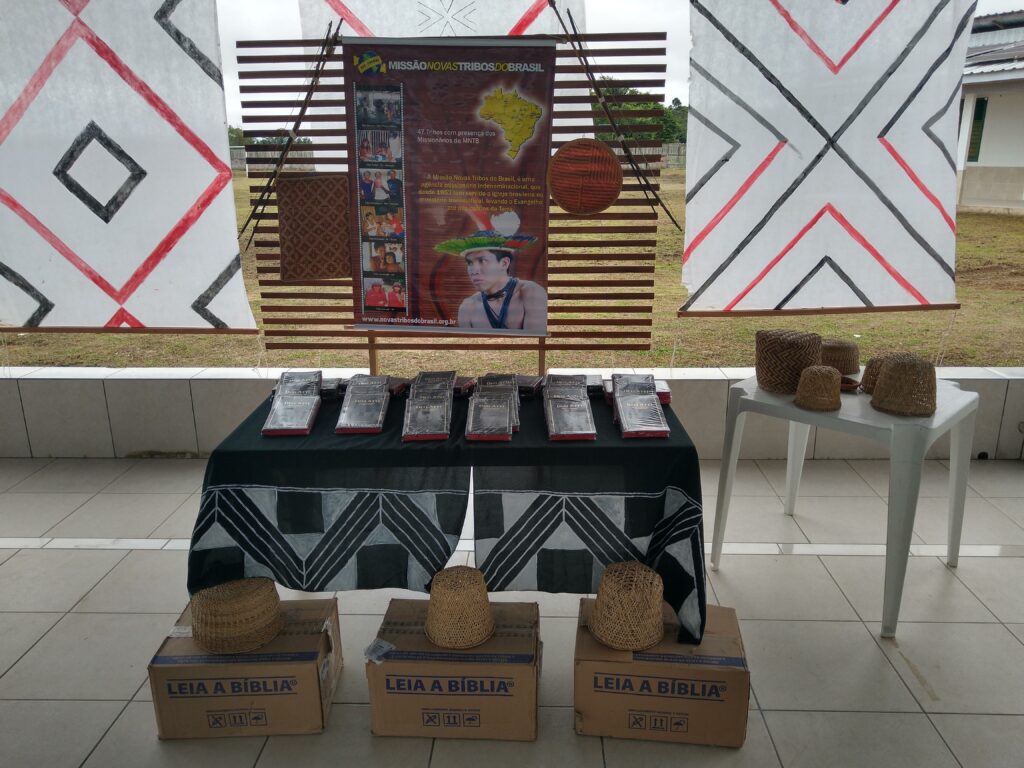
JAARS pilots Jeremiah Deidrich, Jake Anderson, and Craig Russell provided aviation support, along with SIL Brasil and Missão Novas Tribos do Brasil, from 2008–2021.
Solomon Islands: Cheke Holo
12,000 Speakers
Translation began 1985
New Testament dedicated 1994, Published Full Bible 2022
Available in print, audio, and the Jesus film
JAARS provided software development support.
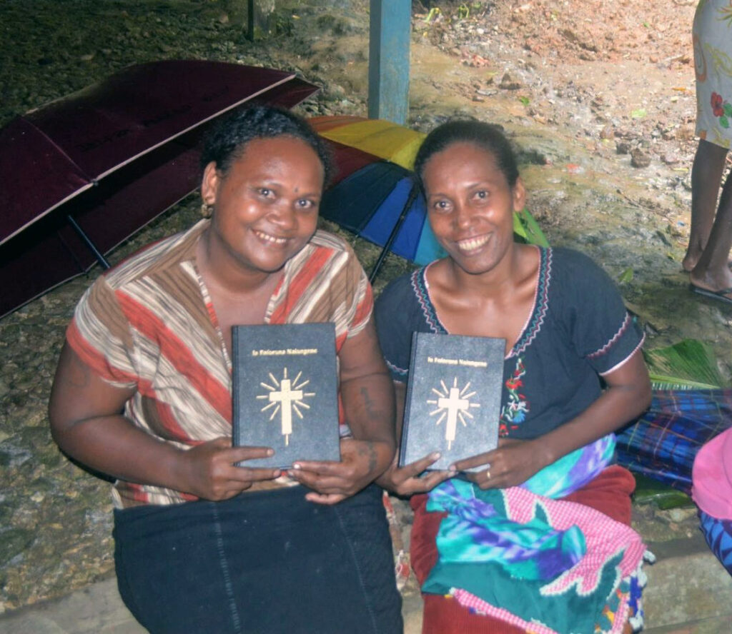
Indonesia: Seko Padang
5,000 Speakers
Published NT 2021, Dedication date September 15, 2022
Available in print, and the Jesus film
JAARS involvement:
Mark & Kirstin Jenkins provided computer support
Bob & Joyce Sterner provided administrative support & personal encouragement
This guide helps detail the steps we take to ensure a thorough and communicative hiring process. From job creation to onboarding, this list helps you understand where you are in the process and what to expect next.
1.Prayer
Before posting a position, we – the Fellows Admin Team – go to the Lord in prayer and ask that He would lead the right candidates to apply and that we would honor Him with our selection.
2.Post & Review
The job gets posted on various sites including the JAARS website and Handshake, among others. We then work to review all applications and resumes submitted. Applications are submitted through our applicant tracking system (ATS). Applicants select the position they are most interested in, create an account in our ATS, and complete the application. If more than one position is of interest, there is a place on the application to mark a second and third position preference.
3.Screen & First Interview
We review and screen candidates, inviting qualified applicants to an initial phone interview with the current HR Fellow. In this interview, we assess competencies and cultural fit, among other things.
4.Check References
If a candidate has a successful first interview, the HR Fellow conducts reference checks with the references provided on the candidate’s application.
5. Second Interview
We then pass along qualified candidates to the hiring manager for further review and a second-round Zoom interview. This interview includes the interviewee, Fellows Coordinator, and hiring manager.
6.Offer Letter Sent
Once those references and interviews are completed, the Fellows Admin Team, along with hiring managers, decide which candidates to invite to join JAARS Fellows. Official offer letters are sent to six candidates for each cohort. Candidates typically have 1-2 weeks to respond to offer letters.
7.Offer Acceptance & Onboarding
Once a candidate accepts their offer, the current HR Fellow coordinates the completion of the criminal background check and all onboarding paperwork. New fellows then register for ICC and stay attentive from correspondence from the HR Fellow and Fellows Coordinator as their start date approaches.
Our hiring process takes anywhere from 30-120 days. The process varies for individuals depending on the position, candidate pool, applicant date, and the cohort for which a candidate is applying.